Monday, February 28, 2022

Sevilla Day 1 – Día de Andalucía


We arrive in Sevilla on Día de Andalucía, February 28th, with news that Russia had fully invaded Ukraine. As we sit down for lunch, a parade marches down Avenida Menéndez y Pelayo, green and white flags headed for the Plaza de España. Our discussion as we consider autonomy, self-determination, and democracy.
ANDALUCÍA POR SÍ, PARA ESPAÑA Y LA HUMANIDAD [Andalusia by herself, for Spain and for Humankind]
After lunch, we search through the alleys for our accommodation. It's nearby, but down some backstreet. We pause as a black Lexus tries to squeeze-in where the street narrows. We hear awful noises. and we realize what those strange triangular wedges at the base of the building are for: they keep the cars off the masonry, like the sides of HotWheels tracks. Still, there are many 'exchanges' between car and building.

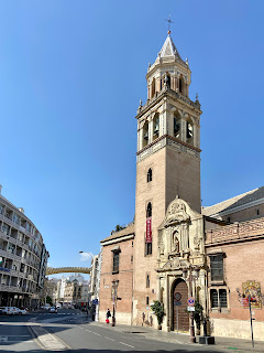
Exploring our new neighborhood, there are towers and churches on nearly every block. The color scheme is super-consistent: sandy tans, dirty reds, other earth-tones, and not much else. However, there are plenty of interesting shapes and silhouettes, and lots of marvelous ironwork and tile mosaics.

The colors remind us of the story of the Ukrainian flag, blue sky over a field of wheat. Once it's in our heads, the colors of the flag appear everywhere.

We pass through the Plaza del Cristo de Burgos and by the Iglesia de San Pedro – some beautiful architecture, a wonderfully shaded park, and just down the Calle Imagen, Las Setas. 


Las Setas de Sevilla creates a novel and forceful disturbance in the urban fabric. We approach it from the Plaza de la Encarnación, near the Iglesia de la Anunciación (sixteenth century); seems ungracious to put this church in the shadows. But, with the holiday, the shops and restaurants are buzzing; the locals are loving it.

Across the Calle Imagen, there are stairs and escalators to the upper level. Only the tourists go up. We peer down on the activity within the older buildings all around.


We stop for a snack in the the Plaza Alameda de Hércules. Though the park itself is old, there are some angular, shady structures, about the same color as the Setas. Not sure how the old and new are supposed to 'blend', if they simply interrupt each other. In any case, it's not a very attractive park, but it s full of smiling people enjoying a warm day.

We reach the Rio Guadalquivir on the Puente de la Barqueta (1989-92). The Guadalquivir is smooth, creamy, and green. There are rowers and boaters gliding on the surface, and others fishing from the plaza. We stand in the shadows of one of the suspension arch beams, as the larger buses and trucks rumble by, the bridge trembles. On the other side of the river we can see a Disney-like collection of objects: a roller coaster, an angled tower (radio station), another tensile structure (a bridge? a ride? no, it's for flamenco), a series of thin steel frames hanging over the Pabellón del Futuro.

Further upstream we also see the Puente de Alamillo (1987-92) one of Santiago Calatrava's earliest bridge designs.

We turn around, and walking in the old city, and within a minute or two, are at the Muralla Almohade (twelfth century). The bridges, walls and gates don't just present the old and the new, they crash into each other in the oddest ways.

Perhaps the most captivating urban details are the tile memorials we find every so often. For example, we find one near the alley of Calle Antonio Susillo, in memory of a sculptor named Antonio Illanes Rodriguez, who passed away in 1976. And at the end of the alley is a glorious tile gateway, 'Maderas', under a tiled image of Nuestra Señora de la Esperanza.


On the way home we stroll by some quite large churches: Iglesia de San Luis de los Franceses (early eighteenth century), Iglesia de San Marcos (fourteenth century, with minaret-like bell tower), and Iglesia de Santa Catalina (thirteenth and fourteenth centuries), Convento de San Leandro (sixteenth century), Monasterio de la Visitacion de Maria de Salesas (nineteenth century).

Also, near our rooms, at the end of another alley, is a freshly-painted red facade with yellow trim – a drop of color in a sea of beige. Those are definitely the colors of the Spanish flag. This alley (Calle Lirio) is a shortcut for our new neighborhood to the north, and the facade quickly becomes a familiar landmark.


Wednesday, February 23, 2022

Tomar e Almourol


Tomar

Our last day in central Portugal begins in Tomar. Two days ago, we made a charge at the Castelo, but today we can linger, stroll, and appreciate this scenic city. We set as our first destination the Ermida de Nossa Senhora da Conceicão (sixteenth century), from the online pictures, a beautifully simple Renaissance interior.

We pause on the Ponte Velha, over the Rio Nabão, and try to deconstruct the engineering. There is a long angled dam with a platform along the top of a wall to a rusty lock, lots of ducks, pigeons, and folks on their morning walks with their dogs. The Ponte brings us to an island park, the Parque do Mouchão. The Parque features overhanging willows, palms, and terrific views up to the Castelo. There is also a water wheel, the Roda do Nabão (early twentieth century), which for architects and history buffs, is endlessly fascinating – the geometry of the timbers, and the pots used to transfer the water:
But the traveller devotes his first attention of the day to a close exmination of the water wheel that is so near at hand that passers-by usually ignore it, perhaps thinking it is merely decorative or is simply some children’s plaything that has been set to one side. Yet as a piece of carpentry, it is one of the finest machines the traveller has seen. It is known as the “Moors’ wheel”, as is common in Portugal when we don’t have any other explanation for something, but in fact experts say it dates from Roman times. The traveller does not know exactly when it was built, but finds it hard to credit that it has been a wheel since “the fourth or fifth century. Far more important than determining whether it is Moorish or late Roman seems to him to be when it stopped functioning, and all the art and science of its use. Everybody has their favourite things: the traveller delights in these functional instruments, small works of art bearing the marks of those who used them. (José Saramago, “Journey to Portugal,” Harcourt, 1990trans Hopkinson-Caistor, 2000)
As we reach the Largo do Pelourinho, we look for the foot of the path that will take us to the Ermida, but the gate is closed. So we begin to walk around the hill, looking for another way. We pass another adorable, domed church, the Capela de São Gregório (sixteenth century), but that, too, is shut. As we continue around, we realize we are circumnavigating an old river bed, and that it will take us far to the north of the Ermida, so we abandon the route, and head back to the Largo.

We set as our new destination, the Aqueduto do Convento de Cristo (early seventeenth century), the troço terminal, where water enters the Refeitório dos Frades and finishes at the 'Templar Cross' fountain at the center of the Claustro Principal. The walk to the Convento is more gradual on this side, with calçadas that seem to lay a smoother path. We can see the Ermida up through the olive trees, and the views to the east are fantastic, under the glow of the rising sun.


Aqueduto do Convento de Cristo

We walk to the far western end of the Convento and there find the Aqueduto, about two stories high. There are dumpsters, and the weeds are overgrown, but the stone arches and finials are intriguing. To the east, we see that it joins the walls of the Convento, but to the west, it seems to bury itself into the hill and behind a long stucco wall. Google Maps tells us that there are ruined constructions and reservoirs on the other side, as the structure continues west.

Strange that the local tourism officials would not try to make more of this; maybe it's a work in progress. We also note the tall building to our right is a private residence, half of it for sale – location, location.


Praça da Republica e o Rio Nabão

We make our way back down to the center of town and the Praça da Republica. The construction workers are just getting started, so we can stand on benches and investigate the church porta, a lavish Manueline ogee arch with (for now) an empty tabernacle, an armillary sphere on the right, and a quinas crest on the left. We turn to honor Gualdim Pais, the legendary Templar Master and 'Fundador de Thomar'; the dark and heroic statue is dated 1938.

We return to the Nabão near the Levada de Tomar, a well-kept island of mill buildings currently being converted to a cultural center. We realize that the angled dam we saw earlier feeds the narrow channel to the west of this island. From here, there are striking riverscapes to the Ponte Velha.


Igreja de Santa Maria dos Olivais

Before leaving town, we include one more site, the Igreja de Sant Maria dos Olivais (thirteenth century), diocesan headquarters of the Order of Christ. It is an example of the 'gótica mendicante' in Portugal. The church is set in a depression below a sandy plaza of gridded paths that cut twelve squares. Near the church is a bell tower, or watch tower, oblique to the grid and the church.

The west facade is dominated by a grande rosácea, seemingly over-scaled for the size of the church, nearly filling the bay between there buttresses. The archivolts and carvings on each side of the porta entrada are heavily worn, but just above the door is a roundel with a pentagram inside a cinquefoil, the Star of King Solomon (the Knights were formed to defend Solomon's Temple). At the very top is the Templar cross.

Above the 'Star' is the letter 'T', marking this as an initiate church for the Order:
9 – corresponds to the letter "T" (Teth), ninth letter of the Hebrew alphabet, and consequently, was the ninth magic letter of the cabalistic alphabet. The "T", the beginning of the word Templar, meant "foundation" and, curiously, the nine entered also in the calculation of the opening of the Templar Cross, who was 36th (dividing this figure by four, corresponding to the number of components of the cross, we have the "9"). We must also take into account that the initial core of the Templars (Poor Knights of Christ) was 1 + 8, or "9", which corresponds to the "Initiation"/"Foundation" of the Order. (José Armando Vizela Cardoso, "The Templar Knights in Tomar", Edições Viera da Silva, 2020)
The 'T' may also form part of a calyx or 'grail' which, as Vizela Cardoso goes on to explain, is a "symbol of scientific and cultural knowledge" that was pursued by the Order.


Entry to the Igreja is down eight steps. We immediately notice that, far above the altar, the pentagram is repeated in a rosette. In the altar is a statue of Nossa Senhora do Leite (Our Lady of Milk, sixteenth century), a slightly unusual subject for an altarpiece.

Along the south wall is are five of chapels, one of them should include the burial tomb of Gualdim Pais. Still, we search the floors and walls for marking that might give us a clue. There are several tablets with various lettering styles marking the ages.


When asked about Gualdim Pais, the attendant waves his hands and points to the second chapel, seeming to say that no one is buried there, yet still motioning to the chapel. There is a statue of Mary Magdalene in an alcove looking up to an angel on the 'button' that covers the vault keystone. On the opposite wall is a wood sign, looking like a taberna menu, listing the Panteão dos Maestros Templarios, about twenty names of the masters from Gauldim Pais (1157-1195) to Lourenço Martins (1291-1295).

The sign, produced in 2011, is not attractive, but the two markers on the wall are fantastic. First is the marker for 'GVALDMVS' with an indicated date of 1233 (MCCXXXIII, though he died in 1195). Above the marker is a re-dedication plaque, from O POVO DE THOMAR (the People of Tomar), dated 1895, on the seventh centenary of his death.

Next to this is another stone with exquisite but indecipherable Gothic lettering, evidently, memorializing Lourenço Martins (LOMRZO).


Aqueduto dos Pegões

Now in the car, and before turning south, we head west to the Aqueduto dos Pegões (late sixteenth and early seventeenth centuries), which is a continuation of the Aqueduto do Convento. Just along the Rua de Saibreiro, we see the low arches and a squat, domed tower with access stairs. On the side wall is a royal inscription, dated 1617.

The single-story arches disappear in the trees to the east, towards the Convento. To the west, the road drops away, and the arches stretch upward. Near the tower, a dirt road passes through and continues along the length of the structure. We hike west and downhill, as the arches rise above us.

As they rise, other structural aids begin to appear, such as shallow buttresses, as well as modern interventions, such as steel plates and tension rods.


Further down the hill, the single-height arch transitions to a double-height arch, with pairs of slim round arches resting on single pointed arches. At the same time, the Aqueduto turns from the northwest to the southwest, then continues across the grassy groves of olive trees, and the Vale dos Pegões. Near its highest point, about 30 meters (one hundred feet), the path rejoins the road. The masonry at the points of the lower arches seems impossible thin, yet the Aqueduto has stood all this time.

We cross the road, and continue down the Rua dos Pegões Altos where we witness the astonishing breadth of the form running between the green hills. Another domed tower breaks the silhouette at the far west.


Returning along the serpentine street, we notice that new(er) concrete foundation have been installed under the arches nearest the traffic. After four hundred years, the heavy trucks must give the blocks quite a shake. We climb the stairs and enter the domed tower.

Inside, there is a lot of graffiti. In the middle of the floor is a square tub, laying at a diagonal to the wall, which could be used to inspect and deliver water. Another low door leads to the top of the Aqueduto, where there is a narrow water channel and a very narrow walkway. Flat stones cover a very few portions of the channel, suggesting that in the past it had been covered, and that some of the local farmers also needed flat stones.


Castelo de Almourol

Finally we turn south and begin our drive to Lisbon. It's only a couple hours, but we decide to break the journey at the Castelo de Almourol. The Castelo dates from 1171, built by Templar Knights on an island in the middle of the Rio Tejo. By 1129, during the Reconquista, the Portuguese controlled most of the land between the Mondego and the Tejo, and the Templar Knights were tasked with its defense.

The Castelo was seriously damaged during the earthquake of 1755, and was rebuilt with 'romantic additions' in the nineteenth century (the battlements and bastions). Though 'inauthentic', these additions present with great effect; the Castelo is stunningly picturesque.

Access to the Castelo is exclusively by boat. The boat-driver takes lunch until two-thirty, which squeezes our schedule with our rental car, so we pass. There are hand-made 'bridges' over the shallow river, but signs are posted that tell us 'crossing is strictly forbidden'. We imagine the boat-driver and local high-school bridge-makers in a decades-long battle.

While we enjoy sandwiches at the nearby cafe, the Portuguese army arrives with heavy-duty trucks and canvas-bottomed boats. Soldiers take stations along the river bank and prepare their equipment. We are on the road before verifying that the Russians might sailing upstream.